Scenery
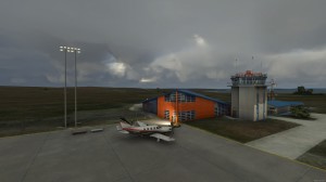
FS2004 Kalocsa Airport VFR Scenery (LHKA) Hungary. STDesign Szab Tam s Includes Kalocsa airport detailed AFCAD and 61 km2 photo area. Full autogen, vegetation, and settlement construction. The scenery does not contain specific objects. By Szabo Tamas. Install scenery. 1. unzip downloaded file 2. create Kalocsa VFR map FSAddon Scenery 3. copy all files, maps to Kalocsa VFR 4. Run FS and open settingscenery library and add scenery. Kalocsa VFR 5. Restart FS 6. Fly!. ) ICAO k d ICAO code LHKA N v Name Kalocsa Poz ci Location 4km 2nm Kalocsa Koordin ta Co-ordinates N463315 E0185636 Magass g Elevation 91m 299ft H v jel Callsign Kalocsa START Frekvencia Frequency 134. 8 NAV AID Forgalmi k r Traffic Pattern LH, RH 1000ft AGL Rep l t r kat. Airport Category Nem nyilv nos fel s lesz ll hely Non pub
Show more... lic take-off and landing Ground zemel s Operating hours SR-SS NVFR nincs nil IFR nincs nil RWY M ret Dimension Talaj Surface TORA (m) LDA (m) Vil g t s Lights 17 35 2500x60 beton concrete 2500x60 2500x60 nincs nil 17 35 1900x300 fu grass 1900x300 1900x300 nincs nil Megjegyz sek Remarks 1. Csak nappali VFR rep l s folytathat Only day VFR flight allowed 2. Nem nyilv nos fel s lesz ll hely Non public take-off and landing Ground 3. A rep l t r a tulajdonos, illetve az zembentart enged lye alapj n vehet ig nybe, kiv ve a k nyszerhelyzetben l v l gij rm veket The airfield can only be used with the authorisation of the owner or operator except aircrafts in emergency Figyelmeztet s Warning 1. LH-P1 6km 3nm NW A D 2. TRA-22F 3. LH-B29 zembentart Operator MRSZ-Aeroport Kalocsa Rep lo Egyes let Remarks. APxxxxx. bgl files repairs more FS visual problems (duplicated runways, ground roughness). These bgl files necessary to all STDesign VFR Scenery.
Show less...


